The Medieval Burgh of Axbridge
by Tracy Kramer
 It
would be easy to miss the tiny town of Axbridge. But if while
traveling down the A371 toward Cheddar and Wells you find your
interest snagged by a sign pointing the way to a "Medieval
Square" you would do well to follow it. The intrigued
traveler who follows the sign will be carried into the heart of a
historical treasure of a town. It
would be easy to miss the tiny town of Axbridge. But if while
traveling down the A371 toward Cheddar and Wells you find your
interest snagged by a sign pointing the way to a "Medieval
Square" you would do well to follow it. The intrigued
traveler who follows the sign will be carried into the heart of a
historical treasure of a town.
The known history of Axbridge stretches as far back as that of
the geological wonder of Cheddar Gorge down the road. There is
evidence of people living in caves in the Mendip Hills, at the
edge of which Axbridge is situated, and the Romans settled and
mined in the area. However, it is with the medieval period that
Axbridge is most closely associated.
The town stocks may have been removed and relegated to the local
museum, but the Square is still the centre of things in Axbridge.
Over the centuries, it has been the site of markets and fairs,
proclamations and punishments. References in the Domesday Book
and elsewhere suggest that the town became an active centre of
commerce in the 10th century. By the 14th century, the town had
become an important player in the wool trade. However, the town's
prominence declined along with the cloth trade in the 17th
century. The Square still has the feel of a marketplace today.
There are shops and places to eat and drink dotted around and, if
you are lucky, your visit to Axbridge might coincide with the
monthly farmers' market.
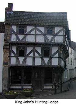
One of the most eye-catching buildings on the Square is the
timber-framed house known as King John's Hunting Lodge. The name
is a little misleading, though. It was unlikely to have really
been a hunting lodge. And as for it belonging to King John? Well,
he died three centuries before it was built. To ease your
puzzlement, step inside. The building houses the excellent local
history museum (free to enter), where three floors of exhibits
and many original architectural features illuminate the history
of the building and of the town. The steep stairs and sloping
floors you encounter as you explore are a reminder of the
building's great age.
 The building was
originally a wool merchant's house dating from around 1500. Its
present name first appeared in a 1915 publication, "The
Heart of Mendip" by Francis Knight, when it was being run as
a saddler's shop. The royal part of the name may have come from
the fact that a carved king's head was found nearby, but whether
this represented John or another king is not known. The head is
now attached to one corner of the exterior. The hunting lodge
identity probably arose from a bit of fanciful tale-telling.
(King John's Hunting Lodge is open daily from 1:00 to 4:00 pm
between Easter and the end of September. At other times of year
it is sometimes open on Saturday and Sunday mornings.) The building was
originally a wool merchant's house dating from around 1500. Its
present name first appeared in a 1915 publication, "The
Heart of Mendip" by Francis Knight, when it was being run as
a saddler's shop. The royal part of the name may have come from
the fact that a carved king's head was found nearby, but whether
this represented John or another king is not known. The head is
now attached to one corner of the exterior. The hunting lodge
identity probably arose from a bit of fanciful tale-telling.
(King John's Hunting Lodge is open daily from 1:00 to 4:00 pm
between Easter and the end of September. At other times of year
it is sometimes open on Saturday and Sunday mornings.)
Radiating off from the Square are several winding streets, which
remain remarkably medieval in character. The brightly painted
houses that line the narrow high street have many original
features, such as sash windows and studded doors. Some houses
have Georgian or Victorian facades, which were added to the
fronts of the earlier buildings. Other original buildings that
remain include the town hall and the almshouse, which was founded
in 1480 and is today a bistro.
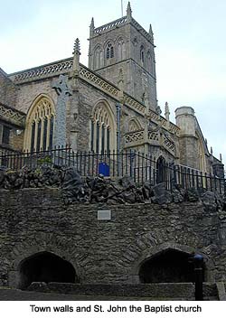
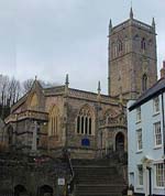
From one corner of the Square you can take a flight of steps up
to St. John the Baptist Church. Parts of the church date back to
the 13th century but most of the present structure is
15th-century. It is an impressive structure built of Mendip
limestone with a lofty tower and intricate exterior.
Architecturally and artistically, there is much to see inside as
well. The nave ceiling, constructed in 1636, bears beautiful
plasterwork against a blue background. Over the south door is the
bread box from which loaves of bread were once distributed to the
poor of the parish. Another noteworthy detail is the 15th-century
carved stone font, which has an interesting history. It was not
until a sexton happened to chip some of the plaster off the font
that the stone decoration was revealed. This had been plastered
over during the Commonwealth when such ornamentation was out of
favor.
 Just
below the church are the original public wells, which were in use
from the Middle Ages up to the 18th century. It is rare to find
town wells like these still complete, in place, and full of
water. A notice nearby explains that during the 16th and 17th
centuries, town laws forbade the dumping of rubbish in or near
these wells. This would have been for the prevention of
disease. Just
below the church are the original public wells, which were in use
from the Middle Ages up to the 18th century. It is rare to find
town wells like these still complete, in place, and full of
water. A notice nearby explains that during the 16th and 17th
centuries, town laws forbade the dumping of rubbish in or near
these wells. This would have been for the prevention of
disease.
Axbridge was never developed during the Industrial Revolution,
which helped to preserve its architecture and layout. It was only
linked up by rail for a short time, via the Yatton-to-Wells line,
between 1869 and 1963. Where this railway, known as The
Strawberry Line, once ran there is now a footpath and cycleway
linking Axbridge with Cheddar and other towns along the line.
Axbridge is a designated conservation area. This protection of
the town's heritage makes it an interesting place to visit and a
very pretty home for its residents. But this town is not merely a
relic; it is far from mummified. It is a colorful, characterful,
vibrant locality that manages to hold onto elements of its past
in an otherwise fast-changing world.
Axbridge is located just off the A371, around 2.5 miles west
of Cheddar. There is parking in the town. Axbridge can also be
reached by bus. Cycle paths link the town to Cheddar and other
nearby towns.
More Information:
We regret that we no longer have the resources to maintain up-to-date links and/or hours and pricing details for the various sites and attractions listed on this website. For more information about the location(s) listed above, please use your favorite search engine or visit Wikipedia.
Tracy Kramer, a native of Tucson, Arizona, studied English at Kenyon College in Ohio. She now lives and works in Bristol, England, where she enjoys writing about organic growing, sustainable living and the British countryside.
Article and photos © 2006 Tracy Kramer
| 