Silbury Hill and West Kennet Long Barrow
by Moira Allen
Just south of Avebury, and generally considered part of the
overall Avebury temple "complex," stands Silbury Hill.
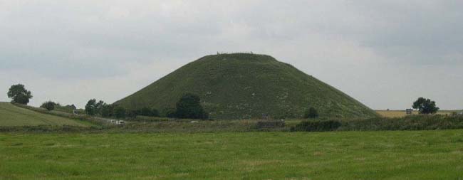
In a county full of prehistoric "mosts," Silbury Hill
is yet another: The tallest man-made prehistoric mound in Europe,
and one of the largest in the world. Rising like a shallow,
flat-topped cone from the fields, it stands 40 meters high and
covers about five acres, with a base 1640 feet in circumference.

Work on the mound began around 2660 BC, during the first week
of August -- a date determined by the discovery of winged ants
and certain types of seeds within the mound. This places the
beginning of construction right around the Celtic harvest
festival of Lughnasad or Lammas, which has led many to speculate
that the mound may be associated with harvest rituals. Another
factor contributing to this view is the fact that the mound
cannot be seen from Avebury until the crops in the intervening
fields have been harvested.
Experts aren't entirely in agreement on how the mound was built.
Some believe that it was built in three stages, starting with a
gravel core contained within a ring of stakes and sarsen
boulders. This core was then covered over with chalk and earth,
most of which was dug from the ditch that once surrounded the
mound. It's not clear whether this ditch was dug intentionally
(perhaps to be filled with water to form a sort of reflecting
pool), or whether it was simply a byproduct of the quest for
building material, as it was subsequently filled in. The final
phase of construction involved building six concentric terraces,
which were then filled in and smoothed over with more rubble and
chalk (which was by this time being brought from elsewhere). Only
one terrace remains, about 17 feet below the summit. In all,
more than 12 million cubic feet of chalk and earth went into the
building of the mound.

Originally the mound was thought to have been built in
concentric layers, like a cake (hence the terraces). Another
view, however, is that it was actually built in a spiraling
pattern, rising from the bottom to the top. Again, experts
disagree on why this might have been the case. Some believe that
the spiral indicates a ritual processional path to the top of the
mound; others believe that this was simply a much easier method
of construction than the layer-cake approach. Given that the
terraces of the mound were apparently smoothed over as
part of the original construction process, and not at some
later time, the second theory seems more likely; if the spiral
had been intended as a road, one would imagine that it would have
remained in use for a period of time before being covered over.
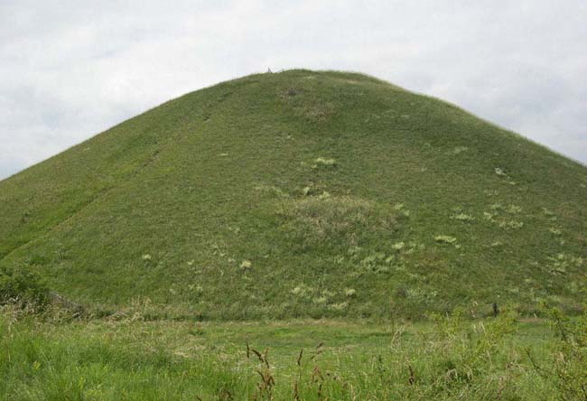
In fact, the mound does not appear to have been designed to have
been "climbed" at all; its smooth walls do not permit
one to simply walk up to the top, without carving a new pathway
(which, based on drawings of the site by William Stukeley in his
18th-century book Abury - A Temple of the British Druids,
appears to have been done in later times). Quite possibly,
therefore, the mound was not built to be used, so much as
to be observed from another location.
As to the purpose of the mound, the only thing that theorists
can truly agree upon is that no one really knows. Theories
abound, linking the mound to fertility rituals, harvest rituals,
the Mother goddess, ley lines, and even "dragon lines"
(based on its resemblance to lung-mei mounds in China).
Local legend attributes the mound to the devil, who was planning
to dump a load of earth on nearby Marlborough but was prevented
by the priests at Avebury. In another version, it is a clever
cobbler who thwarts the devil. The cobbler was bringing home a
load of shoes to repair when Old Nick confronted him and asked,
"Old Cobbler, is it far to the town of Marlborough?"
Perhaps noting that his questioner's feet wouldn't have fit into
any of the shoes that he was carrying, the cobbler quickly
replied that it was far indeed, for he had worn out all the shoes
in his pack trying to get there! Discouraged, the devil gave up
his plan and dropped his load of earth by the side of the
road.

Yet another theory, still prevalent in the 18th century, was
that the mound was the barrow of a great king named
"Zel" or "Sil." Zel was thought to have been
buried sitting upright upon his horse (which was perhaps meant to
explain why such a tall mound was needed). A variant upon this
theory was that the mound housed a life-size gold statue of a
horse and rider. This is the theory that Stukeley ascribes to.
Stukeley claims that the remains of a horse and rider were indeed
discovered in 1723:
In the month of March, 1723, Mr. Halford order'd
some trees to be planted on this hill, in the middle of the noble
plain or area at top, which is 60 cubits diameter. The workmen
dug up the body of the great king there buried in the center,
very little below the surface. The bones extremely rotten, so
that they crumbled them in pieces with their fingers. The soil
was altogether chalk, dug from the side of the hill below, of
which the whole barrow is made. Six weeks after, I came luckily
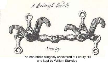
to rescue a great curiosity which they took up there; an iron
chain, as they called it, which I bought of John Fowler, one of
the workmen; it was the bridle buried along with this monarch,
being only a solid body of rust . I immerg'd it in limner's
drying oil, and dry'd it carefully, keeping it ever since very
dry. it is now as fair and entire as when the workmen took it
up... There were deers horns, an iron knife with a bone handle
too, all excessively rotten, taken up along with it.
This, however, is the only record of any sort of burial
uncovered upon the mound, and judging not only by Stukeley's
description of its proximity to the surface, but also by his
drawing of the bridle itself, it must have been considerably
later than the construction of the hill.

Excavations into the interior of the mound have been conducted
in 1776, 1849, and 1967, but all have proven disappointing in
terms of uncovering artifacts or any indications of the purpose
of the mound. The only artifacts discovered within the mound
seem to relate to its construction (or perhaps to the
construction workers' lunches), and include various twigs, antler
tines, grains, flints, clay, ox bones and freshwater shells.
Unfortunately these shafts were not always filled in correctly,
leading to subsequent erosion and slippage of the mound itself.
In fact, more Roman artifacts have been found in and around the
mound than any other, including more than 100 coins in the ditch
that once surrounded the mound, and a platform cut into the mound
containing ashes from burnt artefacts. Many other Roman shafts
and wells have been found nearby, and Stukeley's illustrations
point out a "Roman camp" not far from Silbury. And
even as this article was being written, archaeologists discovered
evidence of a large-scale Roman settlement at the base of the
hill that no one had previously known about. This village
straddles the Roman main road where it crossed the River Kennet,
and was laid out with buildings and streets perpendicular to a
main north-south thoroughfare. The Roman Road itself breaks the
usual ruler-straight pattern of most such roads, to detour around
the hill. The village was discovered by non-invasive sensing
equipment during the process of restoring damage to the hill.
Today Silbury Hill stands on private land and is fenced in to
prevent climbers from causing further damage and erosion. It can
be viewed from the road or from a small carpark nearby. Sadly,
many people ignore the posted signs and fences and clamber up the
slope anyway; a rather scruffy-looking bunch of visitors was
doing just that when we viewed the mound, and then descended to
have a picnic at its base. So perhaps it is best to observe the
mound as its builders probably did: From a respectful distance.
West Kennet Long Barrow
 Close by Silbury Hill and yet another on the list of
"biggest" in Wiltshire is the West Kennet Long Barrow,
one of the largest chambered barrows in Britain. (Wiltshire, by
the way, holds the record not only for "biggest" but
"most," as it contains 148 of Britain's 260 long
barrows; to get an idea of their density, just stand on the grass
at Stonehenge and survey the skyline!) Close by Silbury Hill and yet another on the list of
"biggest" in Wiltshire is the West Kennet Long Barrow,
one of the largest chambered barrows in Britain. (Wiltshire, by
the way, holds the record not only for "biggest" but
"most," as it contains 148 of Britain's 260 long
barrows; to get an idea of their density, just stand on the grass
at Stonehenge and survey the skyline!)
West Kennet Long Barrow, which is managed by English Heritage,
stretches more than 320 feet from east to west and stands 8 feet
high. Only a small section of the barrow, however, was actually
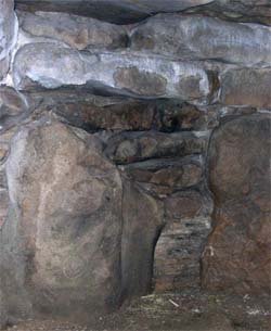
used for burials. From the upright sarsen stones at the entrance
(which were repositioned in 1956), one enters the forecourt, and
thence into a passage grave that extends about 33 feet into the
barrow. This passage leads to five separate burial chambers: Two
on each side, and a larger polygonal chamber at the end.
Construction on the barrow began around 3600 BC, about 400 years
before the first building began at Stonehenge. It was thought to
have been used as a communal tomb for about 1000 years, though in
all, only about 46 burials have been found, ranging from infants
to old people. Unfortunately, many of the bones had been removed
from these burials, and no one seems quite sure whether this was
done at the time or by subsequent looters. A doctor in the 17th
century was known to have removed several bones for use in
compounding medicines (I'd rather not speculate as to what
kind of medicines!). Eventually the passage and chambers
were filled in with earth and stones, amid which have been found
bits of pottery, bone tools and beads.
As with Silbury Hill, very little is known about the purpose of
the barrow. According to one legend, a ghostly white figure
appears on the mound at dawn on Midsummer, accompanied by a white
hound with red ears. Since this type of hound was traditionally
associated with the underworld and the Wild Hunt (and with later
"fairy" mounds), this suggests that the mound itself
may have been considered an entrance to the underworld at one
time.

Unlike Silbury Hill, you can visit the barrow. You'll
find a small car park outside the village of West Kennet; from
there, you'll hike a steep half-mile to the ridge. Check the
English Heritage website for opening times and tour hours.
More Information:
We regret that we no longer have the resources to maintain up-to-date links and/or hours and pricing details for the various sites and attractions listed on this website. For more information about the location(s) listed above, please use your favorite search engine or visit Wikipedia.
Moira Allen has been writing and editing professionally for more than 30 years. She is the author of seven books and several hundred articles. She has been a lifelong Anglophile, and recently achieved her dream of living in England, spending nearly a year and a half in the history town of Hastings. Allen also hosts the Victorian history site VictorianVoices.net, a topical archive of thousands of articles from British and American Victorian periodicals. Allen currently resides in Maryland.
Article © 2007 Moira Allen.
Silbury Hill photos by Moira Allen; Long Barrow photo by Patrick Allen.
|
