Somerset's Finest Hill Forts
by Tracy Kramer
Somerset is a region of highs and lows. Along the middle and northern parts, low coastline meets the marshy "Levels," while further inland lie the freshwater and peaty marshlands known as the "Moors." Most of this area is no more than 80 feet above sea level. Among these expanses of flatlands lie five ranges of hills: the Mendips, Quantocks, Poldens, Blackdowns, and Brendons. The topography here, as anywhere, has played a role in how the land has been used over the centuries. Climb a hill in Somerset today and you may well see grazing land, roads, low-lying villages. You may also catch sight of drainage channels, locally known as rhynes (pronounced "reens"). These are key to why much of you see is land inhabited and used by people rather than simply being watery marsh. Attempts to drain the marshes date back to the Roman period but the pervasiveness of the water has made the Somerset hills vital sites for settlement, protection, industries such as mining, and farming.
Somerset is home to around 47 hill forts. Many of these defended settlements were established in the fifth and sixth centuries BC and ranged from fairly simple designs, with a single bank and ditch extending around the hilltop, to more sophisticated systems of multiple ramparts and ditches. The Celtic tribes, which in this area included the Dubbuni, Durotriges, and Dumnonii, lived in roundhouses, grew food, grazed animals and traded with one another. The activity of the Iron Age tribes did not halt with the Roman invasion in 43 AD but there is gruesome evidence, for instance at South Cadbury, that some groups put up a strong resistance to the occupiers. The Romans occupied some of the hill forts for only short periods after arriving, although in some cases longer term settlements arose around economic activities such as mining.
After the Roman invaders had moved on, the locals regained the hilltops and many of the hill forts of Somerset continued to be used in various ways. Settlements continued at some of the larger sites. Over the centuries many of the hill tops were used for sending messages via beacon fires, particularly in times of conflict. The Saxons employed these during the Viking invasions and they were likely used in the 16th century and during the Napoleonic wars. The usefulness of some sites, such as Brean Down, continued into the 20th century, with its 19th-century fort being re-armed for defense during the second world war.
Today these sites provide a link to the past. As you gaze out over the land from atop one of Somerset's ancient hill forts you cannot help but imagine what it would have been like living there years ago. The sites are also outstanding habitats for wildflowers, butterflies, and other wildlife. A visit to any of the sites below will stimulate the mind and the senses Ð and in most cases provide a good workout, too!
Brent Knoll
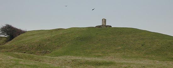
An outcrop of the Mendips, Brent Knoll lies between the village that shares its name and the village of East Knoll. The Romans called the distinctive hill with the dark green hedge lines running up it Mons Ranarum, "The Mount of Frogs." The reasons for this are not entirely clear but the fact that the hill, which today rises 449 feet above sea level, once had a shallow sea lapping around it may provide a clue.
The hill can be climbed from various points. Two possible departure points are the church in East Brent and the church in Brent Knoll village. Either way, signs will direct you to the path to the knoll. Parts of the walk can be very muddy and the route is also quite steep in places. It takes around half an hour to climb to the top.
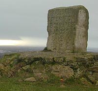
Once at the summit you can walk around the ramparts of the Iron Age hill fort. Few trees impede the panoramic views of the surrounding hills, fields, and villages and the Bristol Channel. It is easy to see that this site would have been a good place to settle and keep an eye on what others in the area were doing. The site was in use in the Bronze Age, too, and probably for centuries before that. When the Romans arrived they built a temple here and coins from the rules of the emperors Trajan and Septimus Severus have been found. A more modern sign of Brent Knoll's symbolic significance comes in the form of a large marker stone commemorating Queen Elizabeth's golden jubilee in 2002.
Dolebury
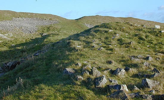
Dolebury, located 15 miles from Bristol, is perhaps the most impressive of the Mendip hill forts. The fort can be approached from a number of paths but no matter which way you enter, once you have scaled its steep sides and taken in its double ramparts, there will be no doubt in your mind that this was a well-protected settlement. It has a one-mile perimeter enclosing 20 acres. Imposing sections of wall remain and also the ruins of a warrener's cottage. The warrener tended the medieval rabbit warren here, with the animals being raised as a reliable source of meat and managed as grazing livestock.
On the slopes sheep graze on land that 2000 years ago was a Celtic field system. Above all, sites like Dolebury functioned as farming settlements. The height of the site would have given the people access to productive ground above the marshes as well as a secure place to build enclosures for their livestock.
The nature reserve on which the hill fort is situated is known as Dolebury Warren and is designated a Site of Special Scientific Interest. The limestone grassland comes alive with wildflowers and butterflies in spring and summer but this is a good place for a dramatic walk at any time of year. The most straightforward route starts at Dolebury Bottom near Churchill village. However, those with a detailed walking map could devise a more involved walk through the adjacent beauty spots of Burrington Coombe or Black Down.
Brean Down
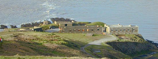
Brean Down is the last outpost of the Mendips. This 1.5-mile long hill jutting into the sea holds both ancient remains and artefacts of much more modern history upon its heights. Like so many of these hill sites, Brean Down would have been used in different ways over thousands of years. The earliest sign found here was a worked deer antler dating to 10,000 BC. By 5000 BC the sea level had risen to make Brean Down an island. Over the next few thousand years the land was bought into cultivation, and two ancient field systems are found here, one of which is thought to be Celtic. The Iron Age fort here dates from around 300 BC and was constructed to protect the entrance to the River Axe. A Roman temple was also built on one of the highest points.
Part of what makes Brean Down particularly interesting to explore are the extensive ruins of the 19th-century fort, which was built as protection against the French. This fort was also used during both world wars. In the interval between these two conflicts part of the fort was used as a civilian caf. In contrast with the more ancient remains, those of such a modern fort provide a great deal of substance. You can even see where the toilets and urinals were!
Today Brean Down is managed by the National Trust who keep it grazed by sheep, goats, cattle, and rabbits, as it would have been centuries ago.
The views from Brean Down are spectacular on a clear day. You can see across the Bristol Channel to Flat Holm lighthouse and Wales. Along the coast you can see the mudflats, the seaside town of Weston-super-Mare, and other coastal settlements, while further inland Brent Knoll and other hills rise from the Levels. This view is likely to change in the not too distant future. As sea levels rise, the sea is likely to reclaim some of the land below the down, which could result in the creation of a valuable salt marsh habitat. As the landscape continues to change, people in this region will once again rely on areas of higher ground.
Ham Hill
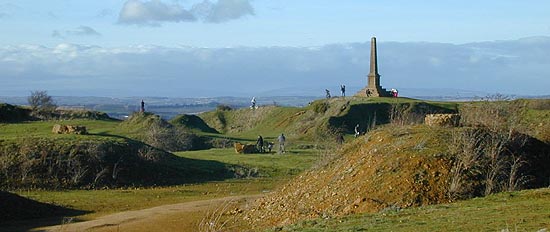
At the Somerset-Wiltshire border lies Ham Hill. This is one of the largest hill forts in Britain and it is also one of the most accessible. A road takes you up onto the site, a country park, from the village of Stoke-sub-Hamdon. There is a great feeling of life here. Not only is this perhaps the only hill fort with a pub (The Prince of Wales), Ham Hill is also an active quarry.
Quarrying work has led to archaeological surveys. Recently several circular pits typical of the ones found at many Iron Age hill fort sites were excavated to reveal artefacts of daily life of the time, including pottery and quernstones. Other digs have revealed evidence of grains being cultivated in the area. These findings support the idea that Ham Hill was the centre of an ordered settlement. Judging by the strip lynchets (medieval farming terraces) below the hilltop, agriculture continued on the site for many centuries.
 You can walk around the outer ramparts, which in their three-mile circle enclose 200 acres. Climbing up to the war memorial will give you views of the surrounding countryside, including Cadbury Castle and the Fosse Way, a major Roman road still in use over much of its extent today.
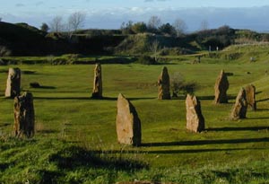
Descend into the protected heart of the fort and you can wander among the stones of a modern stone circle, a millennium project using the highly valued honey-colored limestone that is quarried from the hill.
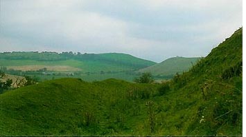
One area of the country park is dotted with tables, making it an ideal place to lay out a picnic. Children, though, will be particularly drawn by the landscape here of grassy humps and bumps. What better setting for a game of Iron Age hide-and-seek?
Cadbury Castle
 Cadbury Castle lies 11 miles from Ham Hill, near the village of South Cadbury. Considered to be one of the most important hill forts in the region, it has been the subject of extensive archaeological work. The ramparts of the Iron Age fort were modified or rebuilt five or six times and there is evidence of a Celtic ironworker's smithy. One of the most intriguing finds was evidence of a massacre at the time of the Roman assault on the fort. This comprised the dismembered skeletal remains of around 30 men, women, and children. The Roman soldiers later returned to burn the gateway over the remains of the last defenders.
Cadbury Castle was fortified again in 500 AD and had a large timber hall. Remains of pottery imported from the eastern Mediterranean and western France indicate that the site was a flourishing town around this time. The scale of trade evident here during the dark ages suggests that this would have been the base of someone important, possibly a king, but certainly a powerful ruler.
Popular belief has it that this ruler may have been the historical basis for King Arthur, with Cadbury Castle his Camelot. This association can be traced back to the Tudor antiquarian John Leland who in 1542 wrote, "At the very south ende of the chirch of South-Cadbyri standith Camallate, sumtyme a famose toun or castelle, upon a very torre or hill . . . The people can telle nothing ther but that they have hard say that Arture much restorid to Camalat."
In the following centuries the site was used as a settlement and fort until its eventual destruction at the beginning of the 11th century on the orders of King Canute as part of the unification of the tribes into the kingdom of England. This ended 4000+ years of occupation, from the Neolithic to the brink of the Norman conquest.
Cadbury Castle is very peaceful for a place with such a tumultuous past. It is certainly not devoid of drama, though. You can approach it from the original roadway and enter through the place where the massacre would have taken place. The four enclosing banks are still dramatic, too, with the ditches between them creating drops of 42, 26, and 38 feet. An air of mystery pervades the site, from the verdant ramparts that draw you along to seek the view just around the corner, to "King Arthur's Palace," the highest plateau of the hill, to the shadowy woods where you can pad among the trees.
Finding Your Way
There is no charge to visit any of these sites. Free parking is available at most. All can also be reached by public transport.
 Brent Knoll
Directions to Brent Knoll village: Exit M5 at Junction 22. At roundabout turn right onto A38. Follow signs to Brent Knoll. Parking available in car park near Manor Farm or in road below the church.
Dolebury
Directions from Bristol: Take A38 south out of Bristol. Continue on road through Churchill then take first left after traffic lights into Dolebury Bottom. Small car park available.
Brean Down
Directions from M5: Leave M5 at Junction 22. Take the B3140 toward Burnham-on-Sea. Follow signs to Berrow and Brean. Road comes to an end near bottom of Brean Down. National Trust car park is adjacent to caf. There is a charge for parking at some times.
Ham Hill
Directions from Taunton: Take the A358 toward the A303. At the junction with the A303 turn left, toward South Petherton. After approximately 9 miles, take the turning for Stoke-sub-Hamdon. Follow the road into the village then follow the sign marked Country Park. There are several car parks. Ham Hill is partly wheelchair accessible.
Cadbury Castle
Directions from Yeovil: Head north out of Yeovil on the A359. At the junction with the A303 turn onto A303 toward Wincanton. Turn right at Chapel Cross and drive into South Cadbury village. Free car park available.
More Information:
We regret that we no longer have the resources to maintain up-to-date links and/or hours and pricing details for the various sites and attractions listed on this website. For more information about the location(s) listed above, please use your favorite search engine or visit Wikipedia.
Tracy Kramer, a native of Tucson, Arizona, studied English at Kenyon College in Ohio. She now lives and works in Bristol, England, where she enjoys writing about organic growing, sustainable living and the British countryside.
Article and photos © 2003 Tracy Kramer
|